The sustainability model for mobility management and planning
Based on the Systems Thinking/System Dynamics approach, the proposed model aims at representing an original approach to sustainable mobility in a mountain context, where sustainability is to be measured according to a composite set of indicators covering the economic, social, landscape/environmental, technical-operational and institutional thematic domains.
Moreover, it will provide a Decision Support Systems (DSS) that is an essential tool for Decision Makers for selecting among various alternatives in a complex and uncertain environment.
The most important goal is to study how different travelling modality (i.e. different splitting of the travelling population in different modality) can affect the overall landscape quality. In addition, the model considers the positive feedback between economic level of the population and number of tourists and, henceforth, the aim is to determine for each splitting in the different travelling modality, the highest sustainable number of tourists.
Main logical steps
The main steps in the model are
- clearly delimit the study area and its boundary,
- identify the points of strength and weakness of the area,
- determine a limited number of tourism attraction points,
- construct shortest path trees based on shortest distances between nodes corresponding to tourism attraction points,
- assign specific values to the auxiliary variables in the model (a large number of these variables are area-dependent or are connected to specific decisions that need to be tested),
- use the System Dynamics model to evaluate the results over time in terms of number of tourists and landscape quality (or any other variable could be of interest to the Decision Maker).
The analysis of the model regions
A first summary exploration of the areas, in which current or potential models of tourist mobility are confronted, cannot avoid considering sufficiently vast and internally diversified territorial areas in order to appreciate the different aspects characterizing them: areas in general, with significant coexistence or proximity to natural spaces, different types of urban areas, or rural areas that are more or less affected by productive or touristic developments.
Their spatial dimension can vary, including large forests or grasslands, more or less protected natural reserves, villages or systems of interconnected villages, valleys crossed by local railways or large tourist centers. These areas, where we concentrate our observations, can be designated as “target sites” or observation areas.
Each site or area of observation exhibits a relatively large number of heterogeneous components that interact among themselves, which applies even more for areas that are historically and biologically complex and diversified. Each component is well-characterized under the structural and functional profile. Because of this, it is important to avoid considering each one (e.g. large forests or grasslands, serial systems of villages, or cultural goods) as areas of observation rather than simple components.
Context definition and landscape features
- Through direct sampling, landscape features of the various contexts have emerged. When defining the model, it will be necessary to measure the evaluations relative to the different transport systems, both existing and programmed, on the basis of these initial characterizations, with particular attention to:
- the landscape character of the site (protected areas or other areas of natural or landscape value), its fragility, its carrying capacity, and the elements present that detract from the landscape or environment;
- current ways to reach the site, evaluating their possible critical limits;
- intersections and continuity within slow systems at the site in question and fast systems to reach or cross it;
- the contiguity or proximity between the site and other areas with more accentuated transformational dynamics;
- the information related to each area of observation will be synthesized in a map, several birds-eye view photographs, and the description of the landscape sense of the site, accompanied by explanatory figures and a description of the fragility from the naturalistic point of view, included in the final WP report In the records that follow, one can observe some of the above-mentioned contents.
An example of context definition: PLAIN RURAL WITH INTENSE AGRICULTURE
Context character
THE PANNONIAN BASIN, LIKE MANY OTHER EUROPEAN PLAIN AREAS, TENDS TOWARDS EVER MORE INTENSIVE FORMS OF AGRICULTURE.
Landscape Features
The structure of the landscape presents a very extensive plain morphology. The agricultural network is large, consisting of plots of uniform cultivation. Linear, secondary infrastructures are inserted on the main routes, and connect with small rural settlements designed in strict relationship with the adjacent rural floor. Other arterial networks form along historical routes starting from the main centers. Closure is not visible in the background.
Ecological Features
The fertile terrain allows for the development of the dominant modern agriculture of cereal cultivation. Intensive agriculture is one of the principal threats to biodiversity on the continent. Natural or semi-natural linear elements, such as rows of trees or bushes, are an essential component of this context if an adequate level of biological diversity and functionality of the ecosystems is to be conserved.
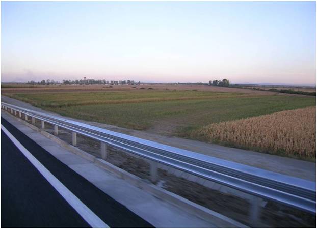
Photo: Near Debrecen, Hungary © UNICAM